LAKESHORE ROAD WEST:
A Multi-Year Battle to Preserve a Scenic Corridor
Questions, answers and info
Scenic Corridor
Open all Close all
-
What Is the Significance of a Scenic Corridor?Scenic Corridors or as they are also called Scenic Roads or Special Character Streets are transportation corridors which have been recognized for the quality and quantity of natural, cultural heritage and recreational features that contribute to their scenic value or special character.
Conservation of scenic roads and special character streets improves quality of life through the protection of biodiversity and native habitats, the enhancement of cultural heritage resources, an increase in recreational opportunities and the provision of economic benefits through tourism opportunities.
All transportation corridors have a varying degree of scenic value, however “the function of transportation corridors is shifting from being a pure capacity conduit for motor vehicles to serving as a part of the community identity and fabric.
”The understanding of the road as a “place” and as a contributing element in the character of its surroundings provides the foundation for the planning, development and conservation of special character streets and scenic roads.
A Bespoke Solution
◦ We have continually asked for the use of context sensitive design in creating the renewal of Lakeshore Road West.
◦ We need to work within the historic context of the road with its mature trees, quaint rural feel and natural drainage features.
◦ Lakeshore Road is a Scenic Corridor. Let's respect its significance.
A Special Study
In 2019, a study was undertaken by Town of Oakville Planning Staff of Lakeshore Road and Trafalgar Road corridors to identify and evaluate the roadway, streetscape and framing elements that contribute to the scenic value. See the "What Were the Results" tab below. -
What Were the Results of the Scenic Corridor Study?Scenic Corridor Study
In 2019, a study was undertaken by Town of Oakville Planning Staff of Lakeshore Road and Trafalgar Road corridors to identify and evaluate the roadway, streetscape and framing elements that contribute to the scenic value.
When the results of the study were presented to Council it included the following findings:- The large mature trees and diverse understory vegetation that frame the corridors are significant contributing elements to the character and context. The street trees provide seasonal diversity and create a visually interesting pattern that frame the view shed.
- Heritage features, such as stone walls and heritage properties, along Lakeshore Road and Trafalgar Road, have a unique relationship with the current corridors and provide a cultural reference back to the historical travel routes. These historical and cultural features significantly contribute to the scenic quality of the corridors and greatly contribute to a sense of identity.
- The presence of sidewalks and paths were identified as important elements because they allow residents to take in and experience other visual scenic qualities of the corridors, such as the mature trees and stone walls, while also providing valuable multi-modal connections across town that contribute to the corridors’ sense of place.
- The complementary attributes associated with the road itself – the framing elements within the boulevard, and how together with the physical road, the corridor is visually perceived as balanced while travelling through.
- Concerns were raised that future road improvements may erode the valuable scenic elements and result in reconstructing the corridor(s) with a singular focus of moving vehicles.
- Maintain the current number and width of the existing vehicle travel lanes where possible. Limit road widening to those areas that accommodate vehicle turning lanes at intersections - where necessary.
- Maintain an appropriate balance between landscaped spaces and hard surface spaces (roadway, sidewalks, etc.) which currently form part of the overall scenic character of the corridors.
- Where physically feasible, incorporate low impact development features/facilities to enhance the ‘greening’ of the boulevard.
The Study asked that its findings be endorsed as a background study informing the preparation of Official Plan policies, urban design direction documents, and future major town projects including the Lakeshore Road West Class Environmental Assessment.
It was given to the project team undertaking the Lakeshore Road West Class Environmental Assessment to inform their design and technical recommendations. And, the Scenic Corridor study team members were to remain engaged in the EA process through to the detail design phases so it could provide expertise on how the key findings can inform the conceptual and final design of the roadway.
Read the Full Report -
How Does Road Urbanization Affect a Scenic Corridor?Good Question!
Urbanized Roads have cross sections that typically include curbs, gutters, catch basins and underground storm water services including grit separators. The addition of elements such as curbs, gutters, man-made stormwater controls (known as gray infrastructure) to a rural road cross-section causes considerable impact, visually and environmentally.
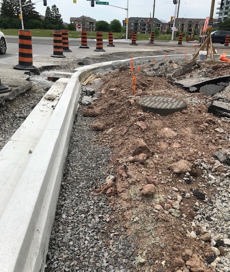
The vast amount of what the Town of Oakville is proposing represents Gray Infrastructure. Below are images of curb construction. It's easy to see how much of the roadside is destroyed in undertaking this work. Trees that are near the road, such as those located at all four corners of the intersection of Third Line and Lakeshore, for instance, will be the victims of curbs if we allow the proposed plan for the road to be used.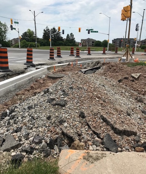
 Many of today's green infrastructure approaches in stormwater control don't depend on below-ground cement pipes, gutters, grit separators and other 'grey infrastructure' solutions that represent 'yesterday's answers'.
We must look for ways to incorporate our existing natural assets with new developments in green infrastructure like those pictured below.
Climate change demands a new way of dealing with stormwater.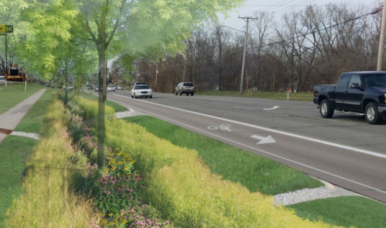
Multi-Use Paths
Open all Close all
-
How Would the Path Proposed by the Town Look?The multi-use path being proposed on the south side of Lakeshore would be 3m wide. To put that in perspective, 3m is slightly under the width of a single road traffic lane.
It is to be positioned immediately adjacent to the road and it is the sole reason why trees would be cut down.
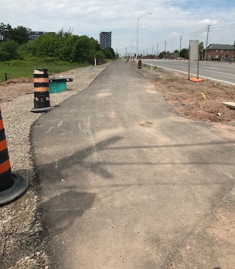
Photo 1 below shows the multi-use path constructed on the north side of Rebecca St. just west of Mississaga Street in Bronte. This is what we could expect to see if such a path is put in place along Lakeshore Road West.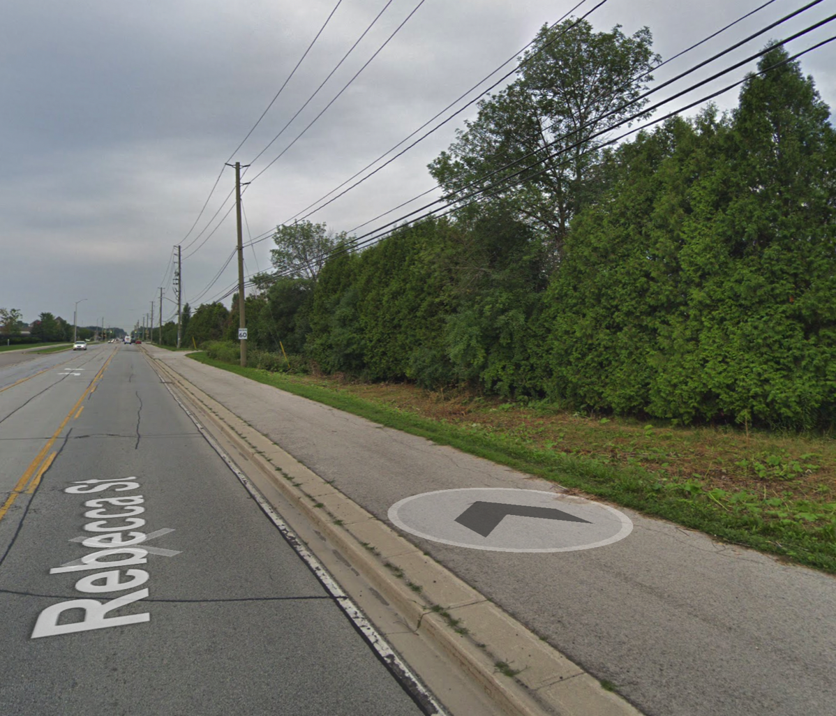 Photo 2.
Photo below shows an area on Lakeshore just east of Bronte Village as it currently exists. The sidewalk, that is in good condition, would be removed and the trees would be cut down. In their place, immediately adjacent to the side of the road a new 3-meter wide asphalt path like the one shown in the photo above would be constructed. It would serve the purpose of a sidewalk and multi-use path.
SPECIAL NOTE: This photo shows the bike lanes already in place in this area of Lakeshore Road West (between East Street and Third Line. You can see the present 'road deck' is wide enough to accommodate bike lanes without having to harm the areas bordering the road.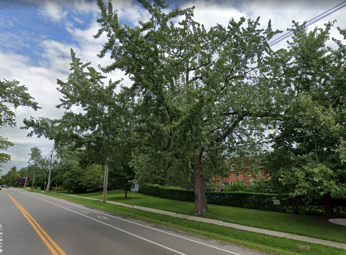
-
Could We Save Trees By Bending the 3-M Path?No, Here's Why
In the communications from the Town, it has been stated that "the town will look for opportunities to further mitigate tree impacts by narrowing the sidewalk or trail, or by curving the sidewalk or trail around trees where possible". In actual fact, to construct a 3m wide multi-use path, it takes at least 5m to do so. The damage caused by the construction of the path is evident in the photos shown.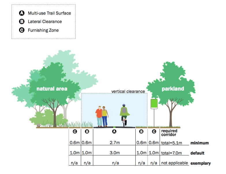
 The image depicting the root system of a tree below shows us that the roots, which spread out from the tree are crucial to its health and survival. They can be very near the surface - as little as 3-5" below.
It is painfully obvious from these images that no 3m path will curve around a tree and simply narrowing it does not prevent the kind of destruction caused by the construction required.
We should not be willing to sacrifice trees for the sake of an asphalt path.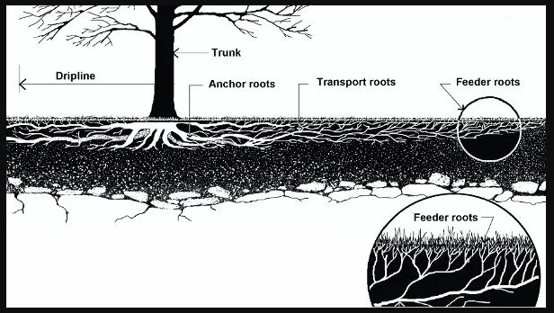
-
What Does the Ontario Traffic Manual Say About the Proposed MU Path?
MU Path/Shared Use Facility
Where numerous low volume driveways or unsignalised intersections are encountered, bicycle lanes may be more appropriate than separated facilities since motorists are more likely to be aware of cyclists on the roadway rather than adjacent to the road.
If bicycle lanes are not feasible, wide curb lanes may be provided. -
What Safety Guidelines Exist for Paths & Sidewalks?The AODA (Accessibility for Ontarians with Disabilities Act) provides guidelines for sidewalks and paths.
AODA for Outdoor Paths: Minimum Requirements
The Standard lists minimum requirements for many aspects of exterior paths.
1. Entrances must have clear openings of at least 850 mm.
2. Paths must have minimum clear widths of 1,500 mm. (1.5m) This width allows room for mobility devices or service animals going both ways along a path. However, parts of a path that connect to a curb ramp can be 1,200 mm wide.
3. Paths must have minimum head room clearances of 2,100 mm. This height ensures that paths are free of obstacles overhead that white canes cannot detect, like signs or tree branches. If part of a path does not have this clearance, that section should have a cane-detectable railing or barrier around it.
4. Paths must have firm, stable, and slip-resistant surfaces that canes, crutches, or the wheels of mobility devices will not sink into.
5. If there are openings in a path’s surface, they must be smaller than 20 mm. This size prevents mobility devices from getting stuck in the openings. Long, narrow openings should be at right angles to the direction of travel.
6. Any change in the level of a path must have a slope or ramp. Similarly, sidewalks with steep or depressed curbs must have curb ramps. All slopes and curb ramps must comply with the requirements for them listed in the Design of Public Spaces Standard.
The continuous sidewalk on the South side of Lakeshore Road W as well as the Multi-Use Path located on the North side between Third Line and Spring Garden Road both meet AODA requirements.
Cycling Facilities
-
Can You Ride a Bicycle on Sidewalks?Children under 11 and the adult who accompanies them are permitted to ride bicycles on sidewalks in Oakville.
-
Are the Paved Shoulders on Lakeshore Suitable for Cycling?
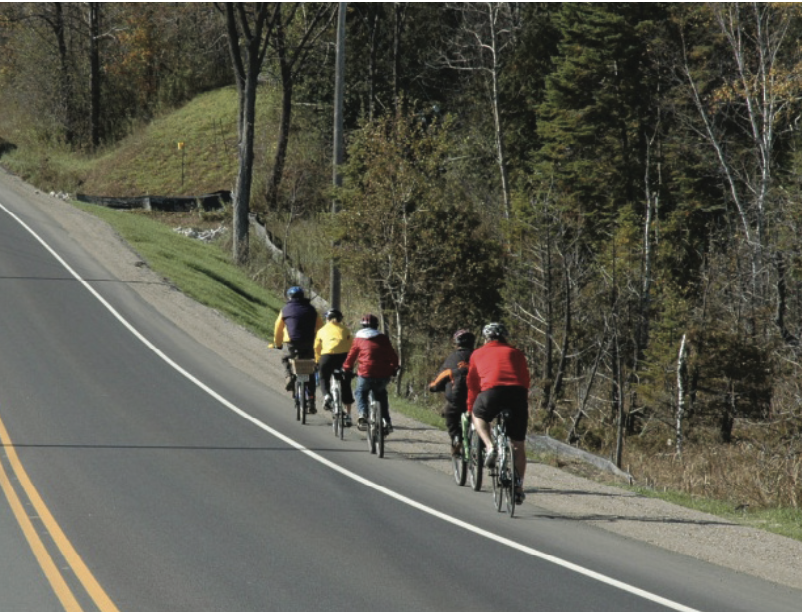 Yes! Here's what we found …
Municipalities often draw on information from the Ontario Traffic Manual, which is series of traffic engineering and traffic control reference manuals produced by the Ministry of Transportation of Ontario (MTO) for use in Ontario. MTO 18 is a manual that provides guidelines on Cycling Facilities.
MTO 18 Guidelines
When designing cycling facilities, multiple aspects should be considered. These include the type of road and its level of traffic, the skill and comfort level of users, the road's speed limit, the space available, etc.- Lakeshore Road West is classified as a Minor Arterial Road.
- It is signed with a 50km/h speed limit.
- The present road deck has the width to accommodate a 1.5m bike lane on each side, or a paved shoulder. A mixture of both are in use at present, with the paved shoulder being wider than 1.5m.
- The level of traffic has remained constant and is not forecast to increase substantially.
- There is a 24-hour/day permanent restriction of heavy trucks on Lakeshore, thus vehicles of that nature are not common on the road.
- Most cycle traffic is recreational.
Bicycle Lanes/Paved Shoulders: Image Above Showing Signed Bicycle Route with Paved Shoulder
This is a road with a rural cross section which is signed as a bike route that also includes a paved shoulder.
A paved shoulder is a portion of a roadway which is contiguous with the travelled way, and is used to accommodate stopped vehicles, emergency use, pedestrians and cyclists as well as for lateral support of the pavement structure.
A paved shoulder on a designated bike route may include a buffer zone to provide greater separation between motorists and cyclists travelling in the same direction.
A signed bike route with a buffered paved shoulder is typically recommended on rural secondary highways, arterials or collectors. The buffer can be made up of two edge lines with or without diagonal hatching. A rumble strip may be provided between the edge lines if it is deemed necessary for the safety of motorists; however, the spacing and shape of the grooves should be as bicycle- friendly as possible. The buffer provides added separation between cyclists and motorists, offering both user groups more comfort as they travel along the roadway.
Open all Close all
Climate, Stormwater & Green Solutions
Open all Close all
-
What is the meaning of a Rural Cross-Section?Rural cross sections consist of a roadway surface of a defined width that includes the lanes, shoulders and ditches which are adjacent to an elevated roadway and are designed to accommodate drainage from the roadway and properties.
-
What is Stormwater Green Infrastructure?
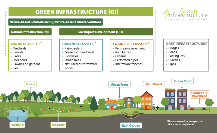 Green Infrastructure or blue-green infrastructure refers to a network that provides the “ingredients” for solving urban and climatic challenges by building with nature. It is a "range of measures that use plant or soil systems, permeable pavement or other permeable surfaces or substrates, stormwater harvest and reuse, or landscaping to store, infiltrate, or evapotranspirate stormwater and reduce flows to sewer systems or to surface waters." By reducing rainwater flows into sewer systems, green infrastructure can reduce pumping and treatment demands for municipalities.
Grey Infrastructure means structural control practices such as gutters, drains, pipes, and retention basins. Examples of Grey Infrastructure include tunnel systems, storage tanks, in-line storage facilities, sewer lines, and high rate clarification treatment facilities.
Currently, Lakeshore Road W has a Rural Cross-Section with a blend of grey and green infrastructure. The green elements are open ditches (swales), natural soil shoulders, abundant greenery including grass, bushes, trees, etc. A great majority of the stormwater that falls during a rain or storm event is absorbed by these natural features. Water runs off the road and is soaked up by the surrounding soil, bushes, trees, etc. Tree roots that fortify the soil help to prevent erosion. Along our streets, the roadside ditches capture the runoff from our streets and homes. As the water is carried away, it is filtered by the ditch and the pace of its movement toward Lake Ontario is slowed. It is doing a great job as Green Infrastructure!
Adding curbs/gutters, means rainwater from Lakeshore that currently falls and is absorbed by roadside ditches, trees and vegetation would run into gutters and be directed to pipes below the road surface.
The Result:
increased runoff
increased contaminants
increased water into Lake Ontario
decreased quality of that water.
Often, when grey infrastructure gives water nowhere natural to go, that water has no choice but to head toward a destination that can’t handle the volume, such as sewers, which then overflow and further pollute the environment.Our position is :
1. Any additional infrastructure that is required to handle our local stormwater should be natural where possible and green if required as new.
2. A detailed review of the areas located to the north of Lakeshore Road be undertaken using a climate emergency lens. Catching, containing and controlling stormwater where it falls should be our goal before we simply revert to adding grey infrastructure to convey more of that water to Lake Ontario. -
Does Lakeshore Road West Need Stormwater Controls Like Gutters, Catch Basins, etc.?No stormwater quantity controls are needed on Lakeshore Road West.
The excerpt from a 2018 Staff Report clearly states the road doesn't need controls. The only time controls are required is if the Urbanization process is undertaken. That process creates a need for receiving systems downstream, to handle the capacity that urbanization would create.
Staff continue to say the grey infrastructure they wish to add below the road is for conveyance. We continue to stress the importance of controlling stormwater "where it falls". This is the approach that is driven by green solutions. If the Lakeshore Road area is threatened by stormwater from areas farther north, stormwater improvements need to happen in those areas first.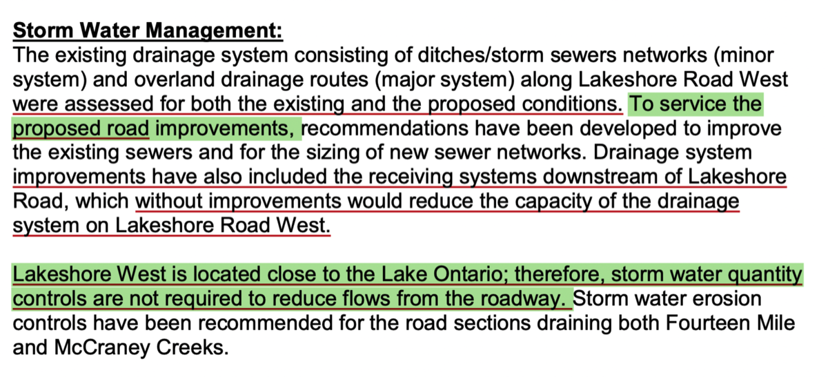
Have a Question That's Not Answered Above? Ask Us!